


Grandview Community Center, Cullman County, Alabama
About
Outline

Summary
| Unique Area Identifier | 521614 |
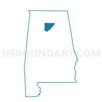
| Name | Grandview Community Center |
| County | Cullman County |
| State | Alabama |
| Area (square miles) | 8.39 |
| Land Area (square miles) | 8.30 |
| Water Area (square miles) | 0.09 |
| % of Land Area | 98.94 |
| % of Water Area | 1.06 |
| Latitude of the Internal Point | 34.11057050 |
| Longtitude of the Internal Point | -86.91515130 |
Maps


Graphs
Select a template below for downloading or customizing gragh for Grandview Community Center, Cullman County, Alabama


Neighbors
Neighoring Voting District (by Name) Neighboring Voting District on the Map
- Baldwin Community Center, Cullman County, AL
- Bethsadia Fire Dept., Cullman County, AL
- Cullman County Health Dept., Cullman County, AL
- Dodge City Town Hall, Cullman County, AL
- Good Hope Town Hall, Cullman County, AL
- Trimble Fire Station, Cullman County, AL
- Valley Grove Community Center, Cullman County, AL
Top 10 Neighboring County Subdivision (by Population) Neighboring County Subdivision on the Map
- Cullman CCD, Cullman County, AL (25,264)
- Bremen CCD, Cullman County, AL (8,283)
- Logan CCD, Cullman County, AL (4,007)
Top 10 Neighboring Place (by Population) Neighboring Place on the Map
Top 10 Neighboring Unified School District (by Population) Neighboring Unified School District on the Map
Top 10 Neighboring State Legislative District Lower Chamber (by Population) Neighboring State Legislative District Lower Chamber on the Map
Top 10 Neighboring State Legislative District Upper Chamber (by Population) Neighboring State Legislative District Upper Chamber on the Map
Top 10 Neighboring 111th Congressional District (by Population) Neighboring 111th Congressional District on the Map
Top 10 Neighboring Census Tract (by Population) Neighboring Census Tract on the Map
- Census Tract 9655, Cullman County, AL (5,631)
- Census Tract 9647, Cullman County, AL (4,643)
- Census Tract 9646, Cullman County, AL (4,007)